

Baldpate Mtn: Pine Grove Hike
Open dawn to dusk year round. During hunting season (Dec-Feb) there are usually closings W-Sa.
(609) 989-6559 Website Google Maps Trail Map GeoPDF
Gravitas: ![]() Challenge:
Challenge: ![]() Proximity:
Proximity: ![]()
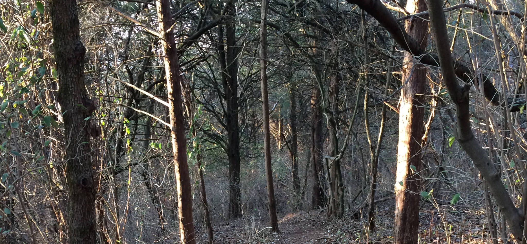
Winding through the Mystery Grove
Note: We love Baldpate Mountain so much, we’ve written four reviews about different aspects of the park: 1) Overview, 2) Switchback Trail, 3) Eastern Trails, 4) Pine Grove Hike (this review). In addition, Fiddler’s Creek Preserve has been added on the other side of Fiddler’s Creek Road.
Parts of this hike are closed until further notice due to August 2021 Tornado damage. Since part of this hike is on unmaintained trails, it’s unclear whether this hike will be passable even after the park is fully reopened.
This has been one of our favorite walks on Baldpate for years, but we’ve never written about it in part because a critical segment was missing from the County’s map. We decided to bite the bullet and create our own map (and in the process correct some minor errors in the County’s). It’s now been updated to our GR series, which you can use in your smartphone as a wilderness GPS. Click on the Trail Map link above.
There are very few stands of pine trees on Baldpate mountain, and this hike takes you through one of them, on a narrow, twisting trail that’s beautiful and fun to walk in almost any season. However, my favorite time to do this hike is in the winter, after a dusting of snow. I usually walk this loop counter-clockwise, so that you come off the ridge with views of Pleasant Valley through the trees (with the leaves down) then descend into the pine grove where the contrast between the green pine needles and the white snow is simply magical. Another great time to walk this is in July when the wild raspberries are in season. This trail doesn’t get nearly the traffic as some of the better marked and mapped trails in the park, and the climb before the descent into the Pine Grove is lined with wild raspberry bushes bursting with ripe fruit.
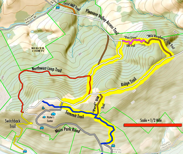
As shown here, this is a 3.8 mile walk, with a cumulative 545 feet of climbing. If I push through the hike without stopping, it takes me about 90 minutes; when I walk it with friends, it’s usually about 2 hours. We’ve debated whether to rate this Intermediate or Experienced. The cumulative elevation gain is a lot for an intermediate hike. However, none of the gradients are terribly long or steep. And while some of the trails aren’t very well marked, I wouldn’t say any of them are difficult to find or follow. The trails are accurately portrayed on our GeoPDF series map of Baldpate, so you won’t get lost if you install it on your smartphone. Note: the Pleasant Valley Access Trail, which connects the Pine Grove segment to the Northwest Loop runs along a stream. During wet seasons it gets extremely muddy, and should be avoided at those times.
The hike starts in the Fiddler’s Creek parking lot and starts up the Summit Trail (blazed blue). Above the stone steps, the trail zigs right and then zags left after 50 yards or so (there is a blue arrow marking the left turn). However, if you stay straight, you’re on the Summit Trail extension. It’s on the County’s latest map as a fully maintained trail, but it’s currently not blazed. Nevertheless after a short climb you’ll come up on a spring-fed farm pond on the right, a brief paved section, which was the driveway of a farmhouse since torn down. Walk on the driveway as high as you can go, and you’ll come to an unpaved woods road which is the Ridge Trail that runs the full length of the Baldpate Preserve. Turn right here.
You’ll walk east on the Ridge Trail for about 3/4 of a mile. You will pass a couple of trails used by hunters which aren’t marked on this map (or any other). The “Wild Raspberry” trail is very clear: it’s in a saddle after a short descent, and nearly as wide as the Ridge Trail itself. Turn left.
Immediately you’ll start a gentle ascent, and when you get to the top (if the leaves are down) you’ll get lovely views of Pleasant Valley through the trees. At the top, the trail turns left and starts to parallel the ridge. The trail levels off briefly, then starts to descend into the critical segment (marked in magenta) which is not plotted on the County’s official park map (which is odd because the “Wild Raspberry” Trail is). Almost as soon as you start descending you’ll be in pine trees. The trail winds down, crosses a little drainage (which is a rill during wet season), winds up briefly, then descends again. As mentioned already, it’s all quite lovely.
The trail segment joins the Pleasant Valley Access Trail at what most times of year is a mud puddle. Make sure you stay left (which is predominantly up hill) and forces you to wade through the mud. If you go right, you’ll end up on Pleasant Valley Rd.
If you’re looking for a slightly more intense hike, try starting on the Rt. 29 trailhead for the Switchback Trail, connect to the Ridge Trail out, and return via the long, western segment of the red-blazed NW Loop. This adds nearly a mile, plus close to 200 vertical feet to the walk.
jim donohue
After hiking to the mid-ppoint of the Ridge trail, I went down the Red trail and went partway down the Blue trail. It appears to have been cleaned up. Fantastic! Next time I’m there, I’ll try hiking it all the around thru your ‘Pine Grove’ section and back to the Ridge Trail.
Your webiste is great. I plan to try a few of the trails you recommended.
Jim
jim donohue
I just did this trail today and it is completely open, from the red trail all the way around to the white trail.
Enjoy your hiking.
Jim
Marty L.
I am looking to walk to the best view of Phila from Baldplate Mountain and could use some direction. I am mildly handicapped and would like the easiest walk possible from my car. Can anyone give some directions?
Admin
I’m unaware of any view of Philly from Baldpate. Sorry.