

Mt. Tammany / Water Gap
Open year round, dawn to dusk
Website Google Maps Trail Map GeoPDF
Gravitas: ![]() Challenge:
Challenge: ![]() Proximity:
Proximity: ![]()
Experience Gap
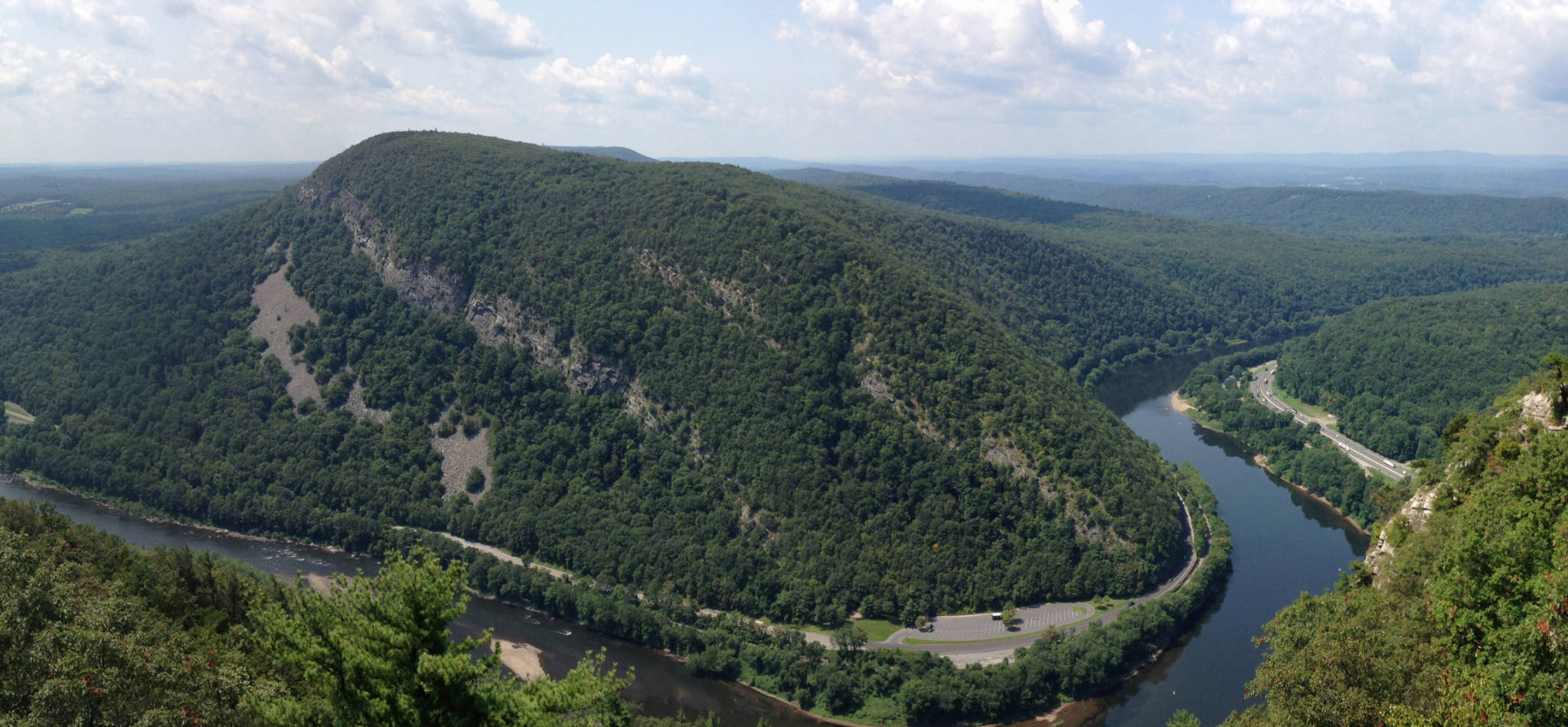
The Delaware Water Gap is one of the geologic wonders of the area, and the Mt. Tammany hike takes you to an awesome, panoramic view of it. Rising more than 1,000 vertical feet from the trailhead, it’s one of the steeper and more challenging hikes you’ll find anywhere in NJ. Accordingly, we rate it for Experienced hikers, though the major challenge is fitness. Fit individuals of any experience level may welcome the opportunity to take it on, though beginners may find the footing challenging in places.
Access to the hike is from the Dunnfield Rest Area which you’ll find on I-80, about half a mile before the bridge to PA, and just before the last exit in NJ. From Trenton it’s about a 90 minute drive up Rt. 31 and 46 if you don’t stop (in summer weekend traffic it can take longer). It’s about the limit of what I consider a reasonable day trip, so you may want to make a weekend of it by camping in Worthington State Forest (there’s a campground just up Old Mine Rd), staying at one of the many B&B’s in the area, or consider a kitschy Poconos honeymoon resort, complete with heart-shaped jacuzzi in every room.
The Dunnfield Parking lot (named after the charming Dunnfield Creek which flows right next to it) is also the trailhead for a popular segment of the Appalachian Trail, so on nice weekends it will fill up. The Mt. Tammany hike actually starts from the next lot east on the same side of I-80. We’ll end the hike on the AT, so you can park in either place (On popular weekends, you may find both lots are full. In that case there’s additional overflow parking on the other side of I-80, which you can access via an underpass, though if you show up before 10 AM you shouldn’t need it.) The park is much less busy during the week, especially Tuesday-Thursday.
If you park at Dunnfield, you’ll find a spur trail heading east from the entrance to the parking lot: you’ll climb up on a shoulder, and hit the Tammany trail after a few minutes of walking. Do NOT start out on the main AT trail along Dunnfield Creek (that’s the way you’ll return). Blazes for the Tammany trail are white painted squares with a red circle in the center.
Almost immediately the trail climbs steeply for about 300 vertical feet, then eases. You’re on top of one of the lower ridges, and there’s a nice view of the Delaware from here. The trail then turns left into the woods, and after a couple of hundred yards of an easy gradient, becomes steep again. For the next 700 vertical feet, the gradient varies between steep and steeper, until it finally starts to ease near the summit. Trails are rocky. Footing is generally good, but decent shoes with lugged soles are essential. You need to pick your steps carefully, and inexperienced hikers may find it challenging.
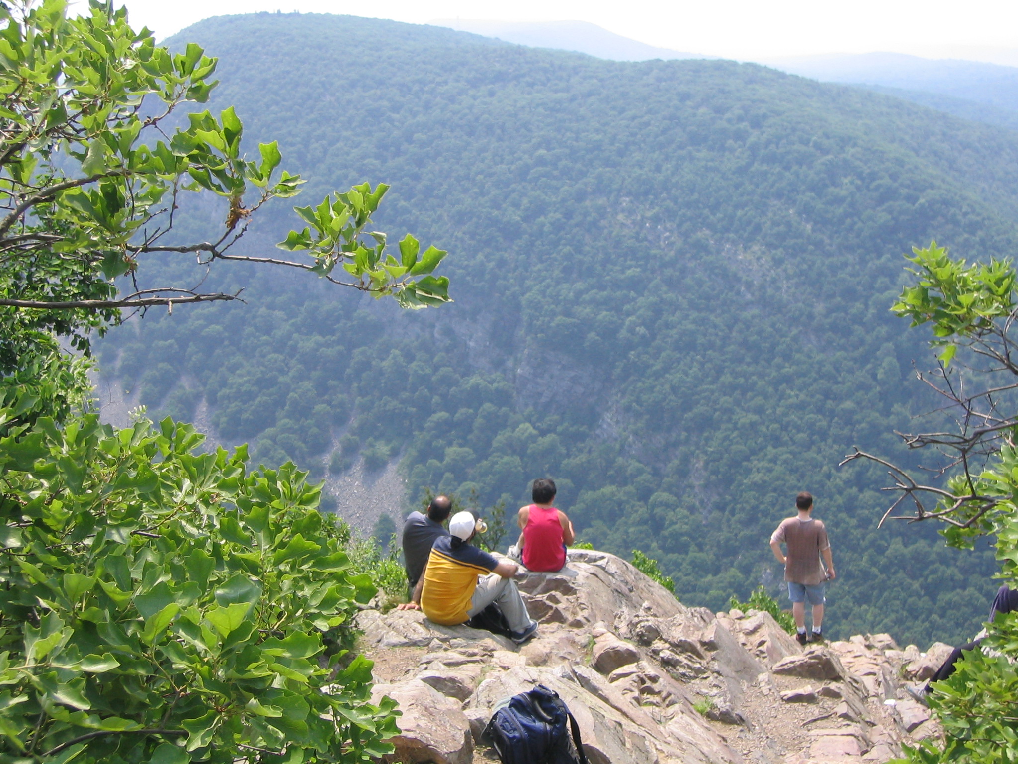
The viewpoint is magnificent, and is accessible from a side trail just before the summit. It looks steep and exposed, but this is largely an illusion. The rock gradient is actually fairly manageable and there’s plenty of room for people to sit and enjoy the sight (and on a busy weekend, they’ll need the room).
To return to the car, you can always go back the way you came. However, I recommend picking up the Blue blazed trail. Just continue up the slope a few yards above the viewpoint. You should see the blue blazes almost immediately. The trail turns east, paralleling the main ridge, then swings north (left) and begins to descend towards Dunnfield Creek. It’s still a long, steep descent, but over about 2.5 miles instead of the 1.5 miles on the red dot trail you ascended.
At the bottom, you’ll hit the green-blazed Dunnfield Hollow Trail, where you’ll make a left to continue the descent (now much more gradual) towards the parking lot. About half a mile from the parking lot, it will merge with the AT, still tracking Dunnfield Creek, which is stunningly beautiful here.
Altogether this walk is about 3.5 miles. For seriously ambitious hikers, there’s an 11 mile variant where you hike along the Mt. Tammany fire road until you reach the Turquoise Trail. You then cut over to Sunfish Pond, and then return via the full length of Dunfield Creek Trail (the trail fords the Creek 5 or 6 times).
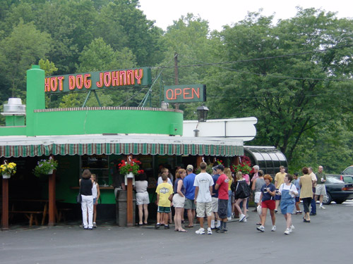
On the drive back, don’t forget to stop at Hot Dog Johnny, a true NJ landmark. It’s on Rt. 46 in the town of Buttzville (really!), a couple of miles before you hit the start of Rt. 31. A hot dog “with everything” includes a slice of dill pickle, chopped onions, and mustard. For a unique Buttzville experience, enjoy them with a mug of buttermilk!
Shawn Most
Copper mine trails a little used but awesome hike as well
Faith Dobry
This is an awesome hike!